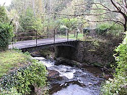
Smart's Bridge
Smart's Bridge | |
|---|---|
 | |
| Coordinates | 51°48′46″N 3°07′13″W / 51.8127°N 3.1202°W |
| Crosses | River Clydach |
| Locale | Llanelly, Monmouthshire, Wales |
| Characteristics | |
| Material | Cast iron |
| Total length | 2.09 m (6 ft 10 in) |
| No. of spans | 1 |
| History | |
| Construction start | 1824 |
| Construction end | 1824 |
| Statistics | |
| Daily traffic | tram (original) / pedestrian |
Listed Building – Grade II* | |
| Official name | Smart's Bridge |
| Designated | 27 July 2000 |
| Reference no. | 23813 |
| Location | |
 | |
Smart's Bridge, Llanelly, Monmouthshire, is a cast-iron bridge situated in Clydach Gorge. Constructed in 1824, it gave access to the Clydach Ironworks, the most significant industrial enterprise in the gorge. The bridge was designated a Grade II* listed structure in 2000.
History
The Clydach Ironworks were established in 1793 by Edward Frere and Thomas Cooke, on land sublet from the Duke of Beaufort.[1] By the early 19th century, the works were the major industrial enterprise in the gorge and Smart's Bridge was built in 1824[2] to give a tramway link from the works to the Clydach Railroad.[3] By the mid 19th century, the firm was heavily in debt, and closed in 1861.[3] The ironworks were bought, firstly, by the Clydach Sheet and Bar Iron Company, and, secondly, by the Brynmawr Coal and Iron Company, and finally closed in 1877.[1]
In 1987, Blaenau Gwent County Borough Council took responsibility for the site, stabilised the remains, and opened it to the public.[1]
Architecture and description
The bridge is a single span, of cast iron, with "lancet tracery in the arch spandrels."[4] The bridge is constructed on rubble piers and is 2.09 meters in length.[1] The railings are replacements from the 1980s.[3]
Notes
- ^ a b c d "Listed Buildings - Full Report - HeritageBill Cadw Assets - Reports". Cadwpublic-api.azurewebsites.net. 2000-07-27. Retrieved 2017-04-16.
- ^ "Smart's Bridge". Graces Guide. 2015-02-05. Retrieved 2017-04-16.
- ^ a b c Good Stuff (2000-07-27). "Smart's Bridge, Llanelly, Monmouthshire". Britishlistedbuildings.co.uk. Retrieved 2017-04-16.
- ^ Newman 2000, p. 281.
References
- Newman, John (2000). Gwent/Monmouthshire. The Buildings of Wales. London: Penguin. ISBN 0-14-071053-1.
{{cite book}}: CS1 maint: ref duplicates default (link)
