Achterberg
Achterberg | |
|---|---|
Town | |
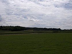
 Corn fields in the direction of Rhenen, seen from Achterberg | |
 | |
 Achterberg in the municipality of Rhenen. | |
| Coordinates: 51°58′18″N 5°35′8″E / 51.97167°N 5.58556°E | |
| Country | Netherlands |
| Province | Utrecht |
| Municipality | Rhenen |
| Population (2007) | |
| • Total | 4,000 |
| Time zone | UTC+1 (CET) |
| • Summer (DST) | UTC+2 (CEST) |
Achterberg is a town in the Dutch province of Utrecht. It is a part of the municipality of Rhenen, and lies about 5 km west of Wageningen.
In 2001, the town of Achterberg had 785 inhabitants. The built-up area of the town was 0.13 km², and contained 228 residences.[1]
References
Wikimedia Commons has media related to Achterberg.
- ^ Statistics Netherlands (CBS), Bevolkingskernen in Nederland 2001 Statistics are for the continuous built-up area.
