Jump to content

Meijel

Coordinates: 51°21′N 5°53′E / 51.350°N 5.883°E / 51.350; 5.883
From Wikipedia, the free encyclopedia

This is an old revision of this page, as edited by InternetArchiveBot (talk | contribs) at 03:36, 28 November 2017 (Rescuing 1 sources and tagging 0 as dead. #IABot (v1.6.1) (Balon Greyjoy)). The present address (URL) is a permanent link to this revision, which may differ significantly from the current revision.

Meijel
Méél
Town and former municipality
Flag of Meijel
Coat of arms of Meijel
Map
Coordinates: 51°21′N 5°53′E / 51.350°N 5.883°E / 51.350; 5.883
CountryNetherlands
ProvinceLimburg
MunicipalityPeel en Maas
Time zoneUTC+1 (CET)
 • Summer (DST)UTC+2 (CEST)

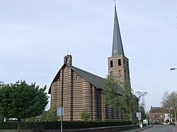
Meijel (pronunciation) (Template:Lang-li) is a former municipality and a town in southeastern Netherlands.

51°21′N 5°53′E / 51.350°N 5.883°E / 51.350; 5.883