
Krimpen aan de Lek
Krimpen aan de Lek | |
|---|---|
 Flag  Coat of arms | |
| Coordinates: 51°53′35″N 4°37′39″E / 51.89306°N 4.62750°E | |
| Country | Netherlands |
| Province | South Holland |
| Municipality | Krimpenerwaard |
| Population (2006) | 6,540[1] |
51°53′35″N 4°37′39″E / 51.89306°N 4.62750°E

Krimpen aan de Lek is a town on the Lek River in the municipality of Krimpenerwaard, province of South Holland, the Netherlands. It had 6,607 inhabitants in 2008.[2]
The name Krimpen comes from the archaic word "Krempener", meaning "river crossing". Therefore Krimpen aan de Lek means "Crossing on the Lek".
Krimpen aan de Lek is a quiet and scenic village with 3 elementary schools.
Krimpen aan de Lek was a separate municipality until 1985, when it merged with Lekkerkerk to create the new municipality of Nederlek.[3]
Gallery
-
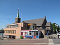 Krimpen ad Lek, church
 -
 Krimpen ad Lek, water tower
 -
 Krimpen ad Lek, view to a s treet


References
- ^ Gemeente op maat, CBS, 2006[permanent dead link]
- ^ Gemeentegids 2008 Nederlek
- ^ Ad van der Meer and Onno Boonstra, Repertorium van Nederlandse gemeenten, KNAW, 2011.
External links
- Template:Kuyper Map of the former municipality, around 1868.
This South Holland location article is a stub. You can help Wikipedia by expanding it. |