
Lac de Mauvoisin
| Lac de Mauvoisin | |
|---|---|
 View of the lake from the dam, July 2008 | |
| Location | Valais |
| Coordinates | 45°59′53″N 7°20′58″E / 45.99806°N 7.34944°E |
| Type | reservoir |
| Primary outflows | Dranse de Bagnes |
| Catchment area | 113.5 km2 (43.8 sq mi) |
| Basin countries | Switzerland |
| Max. length | 4.9 km (3.0 mi) |
| Surface area | 2.08 km2 (0.80 sq mi) |
| Max. depth | 180 m (590 ft) |
| Surface elevation | 1,961 m (6,434 ft) |
Lac de Mauvoisin is a reservoir in the canton of Valais, Switzerland. The reservoir is formed by the Mauvoisin Dam, which is 250 m high. The dam is currently the 11th highest in the world, and the 6th highest arch dam. It was built in 1951–1957, and raised by 13.5 m in 1991.
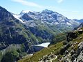
The reservoir lies in the upper Val de Bagnes, between the massif of the Grand Combin, one of the highest mountains of the Alps, and La Ruinette. The highest peak visible from the lake is the Combin de la Tsessette (4,135 m).
Gallery
-
 Mauvoisin Dam, with Mont Blanc de Cheilon in the background
 -
 Dranse de Bagnes, a stream flowing from the Mauvoisin lake


External links
This article includes a list of references, related reading, or external links, but its sources remain unclear because it lacks inline citations. (November 2014) |
- Swiss Dams: Profile of Mauvoisin
 Media related to Lac de Mauvoisin at Wikimedia Commons
This Valais location article is a stub. You can help Wikipedia by expanding it. |