
Shenik, Aragatsotn
40°27′55″N 43°55′47″E / 40.46528°N 43.92972°E
Shenik Շենիկ | |
|---|---|
 Former settlement of Shenik | |
 Shenik Շենիկ | |
| Coordinates: 40°26′40″N 43°56′00″E / 40.44444°N 43.93333°E | |
| Country | Armenia |
| Marz (Province) | Aragatsotn |
| Time zone | UTC+4 ( ) |
Shenik is a former settlement and an abandoned village in the Aragatsotn Province of Armenia. It is 3 km east of the Mastara village, and is home to the 5th-century church of Surp Amenaprkich (Holy Saviour), and the 7th-century church of Surp Astvatsatsin (Holy Mother of God).
Gallery[edit]
-
 Settlement Shenik, general view
 -
 Settlement Shenik, Surb Astvatsatsin (Surb Sargis) Church
 -
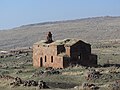 Surb Astvatsatsin (Surb Sargis) Church
 -
 Surb Astvatsatsin (Surb Sargis) Church
 -
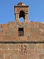 Surb Astvatsatsin (Surb Sargis) Church
 -
 Surb Astvatsatsin (Surb Sargis) Church
 -
 Settlement Shenik, Surb Amenaprkich Church
 -
 Surb Amenaprkich Church
 -
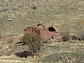 Surb Amenaprkich Church
 -
 Surb Amenaprkich Church, tombstone
 -
 Settlement Shenik
 -
 Settlement Shenik
 -
 Settlement Shenik

_Church4.jpg)
_Church3.jpg)
_Church2.jpg)
_Church1.jpg)
_Church5.jpg)


References[edit]
- Kiesling, Rediscovering Armenia, p. 19, available online at the US embassy to Armenia's website

This article about a location in Aragatsotn Province, Armenia is a stub. You can help Wikipedia by expanding it. |