Jump to content

Demoso Township

Coordinates: 19°32′18″N 97°09′32″E / 19.538319°N 97.158813°E / 19.538319; 97.158813
From Wikipedia, the free encyclopedia

This is an old revision of this page, as edited by Ninjastrikers (talk | contribs) at 12:19, 6 July 2018 (correct coordinates). The present address (URL) is a permanent link to this revision, which may differ significantly from the current revision.

Demoso Township
ဒီမောဆိုး‌မြို့နယ်
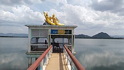
Ngwe Taung Dam located within Demoso Township
Map
Country Burma
StateKayah State
DistrictLoikaw District
Time zoneUTC+6:30 (MST)

Demoso Township (Template:Lang-my) is a township of Loikaw District in the eastern part of Kayah State in Myanmar.[citation needed]

The principal town lies at Demoso. Template:Demoso Township

19°32′18″N 97°09′32″E / 19.538319°N 97.158813°E / 19.538319; 97.158813