
Ostercappeln
Ostercappeln | |
|---|---|
 Saint Lambert Church | |
 Coat of arms | |
Location of Ostercappeln within Osnabrück district  | |
 Ostercappeln  Ostercappeln | |
| Coordinates: 52°21′N 08°14′E / 52.350°N 8.233°E | |
| Country | Germany |
| State | Lower Saxony |
| District | Osnabrück |
| Subdivisions | 3 |
| Government | |
| • Mayor | Rainer Ellermann (CDU) |
| Area | |
| • Total | 100.18 km2 (38.68 sq mi) |
| Elevation | 73 m (240 ft) |
| Population (2022-12-31)[1] | |
| • Total | 10,251 |
| • Density | 100/km2 (270/sq mi) |
| Time zone | UTC+01:00 (CET) |
| • Summer (DST) | UTC+02:00 (CEST) |
| Postal codes | 49179 |
| Dialling codes | 05473 |
| Vehicle registration | OS |
| Website | www.ostercappeln.de |
Ostercappeln is a municipality in the district of Osnabrück, in Lower Saxony, Germany. It is situated in the Wiehengebirge, approx. 15 km northeast of Osnabrück.
Mayor
Since 2001: Rainer Ellermann
-
 Mill island in Venne
 -
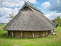 Replica of an Iron Age house in Darpvenne
 -
 Ludwig Windthorst Memorial
 -
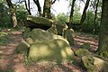 Megalithic chambered tomb "Darpvenner Steine I"
 -
 Megalithic chambered tomb "Darpvenner Steine II"
 -
 Megalithic chambered tomb "Darpvenner Steine III"
 -
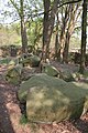
 Megalithic chambered tomb "Driehauser Steine"
 -
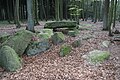
 Megalithic chambered tomb "Dübberort I"
 -
 Megalithic chambered tomb "Dübberort II"


International relations
Ostercappeln is twinned with:
 Bolbec, France, since 1966
Sons and daughters of Ostercappeln

- Ludwig Windthorst (1812-1891), politician
- Michael Hohnstedt (born 1988), German footballer
- Timo Beermann (born 1990), German footballer
References

| International | |
|---|---|
| National | |
| Geographic | |
This Osnabrück district location article is a stub. You can help Wikipedia by expanding it. |