Santpoort-Zuid
Santpoort-Zuid | |
|---|---|
Village | |
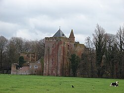
 Castle Brederode | |
 | |
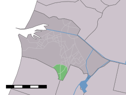
 Santpoort-Zuid in the municipality of Velsen. | |
| Coordinates: 52°25′N 4°38′E / 52.417°N 4.633°E | |
| Country | Netherlands |
| Province | North Holland |
| Municipality | Velsen |
| Population (January 1, 2005) | |
| • Total | 3,280 |
| Time zone | UTC+1 (CET) |
| • Summer (DST) | UTC+2 (CEST) |
| Website | Tourist Info about Santpoort |
Santpoort-Zuid is a village in the Dutch province of North Holland. It is a part of the municipality of Velsen, and lies to the west of North-Haarlem (Schoten). Santpoort-Zuid is bordered by the village of Bloemendaal to the south and the village of Santpoort-Noord to the north. There is a railway station in the village with a connection to Amsterdam Centraal. A famous historic site in Santpoort-Zuid is the Ruin of Brederode, and the formerly well maintained Natuurbad, Velserend.
The village is an upscale neighborhood with Dutch professionals residing there. It is one of the rare coastal forested areas protected by large dunes.
The statistical area "Santpoort-Zuid", which also can include the surrounding countryside, has a population of around 3280.[1]
Near the village is the ruin of the 13th century Castle Brederode.
Railway station
References
- ^ Statistics Netherlands (CBS), Statline: Kerncijfers wijken en buurten 2003-2005. As of January 1, 2005.
