Ysyk-Ata
Appearance
| Ysyk-Ata River | |
|---|---|
 Issyk-Ata River | |
| Native name | Ысык-Ата дарыясы Error {{native name checker}}: parameter value is malformed (help) |
| Location | |
| Country | Kyrgyzstan |
| Region | Chuy Region |
| District | Ysyk-Ata District |
| Physical characteristics | |
| Source | |
| • location | Kyrgyzstan |
| Mouth | Chu River |
• location | Chu Province, Kyrgyzstan |
• coordinates | 42°58′22.17″N 74°54′10″E / 42.9728250°N 74.90278°E |
| Length | 81 km (50 mi) |
| Basin size | 558 km2 (215 sq mi) |
| Discharge | |
| • minimum | 1.6 m3/s (57 cu ft/s) |
| • maximum | 45.8 m3/s (1,620 cu ft/s) |
| Basin features | |
| Tributaries | |
| • right | Byty River |
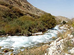
The Ysyk-Ata River (Kyrgyz: Ысык-Ата дарыясы) is a river in Ysyk-Ata District of Chuy Region of Kyrgyzstan. It is a left tributary of Chu River. The length of the river is 81 km, watershed - 558 m2,[1] weighted average elevation - 3030 m, annual average flow rate - 7.05 m3/s.[2]
References
- ^ Чүй облусу:Энциклопедия [Encyclopedia of Chuy Oblast] (in Kyrgyz and Russian). Bishkek: Chief Editorial Board of Kyrgyz Encyclopedia. 1994. p. 718. ISBN 5-89750-083-5.
- ^ "Basic hydrographic characteristics of rivers of Chu River basin". Retrieved 2010-03-12.
