
Rizoma
This article needs additional citations for verification. (December 2009) |
Rizoma
Ρίζωμα | |
|---|---|
Settlement | |
 Rizoma | |
| Coordinates: 39°39′54″N 21°44′02″E / 39.665°N 21.734°E | |
| Country | Greece |
| Administrative region | Thessaly |
| Regional unit | Trikala |
| Municipality | Trikala |
| Municipal unit | Paralithaioi |
| Population (2011)[1] | |
| • Community | 917 |
| Time zone | UTC+2 (EET) |
| • Summer (DST) | UTC+3 (EEST) |
Rizoma (Greek: Ρίζωμα, before 1927: Σκλάταινα - Sklataina[2]) is a village in the Trikala regional unit, Thessaly, Greece. In the 2011 census it reported 917 residents.[1] It lies at 160 meters above sea level, 12 km north of the city of Trikala. It has an agricultural economy with tobacco being the main product.
The village is the seat of the Paralithaioi municipal unit and it is inhabited by Karagounides, the most commonly used name for the residents of the Thessalian plain. According to the legend this name was given to them by Alexander the Great when he passed through the region in 335 BC on his way to Thebes.
The most prominent figure that was born there was the priest-monk Saint Theophilus (mid-16th century) who is recorded as the founder of the Saint Stephen Monastery in Meteora.
To the north of the town, there is a low hill called Tzougza, where trenches dug in WW2 can still be seen.
-
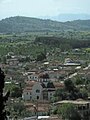 Rizoma in May 2008 showing its main church St Paraskevi.
 -
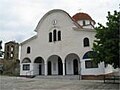 St Paraskevi
 -
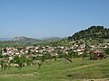 View of Rizoma looking North West from Bordovoullo hill. Tzougza hill visible at right of photo; Theopetra visible in the background; Meteora in the distance.


References
- ^ a b "Απογραφή Πληθυσμού - Κατοικιών 2011. ΜΟΝΙΜΟΣ Πληθυσμός" (in Greek). Hellenic Statistical Authority.
- ^ Name changes of settlements in Greece