Chateau Bay
Appearance
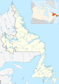
Location of Chateau Bay in
Newfoundland and Labrador
Chateau Bay (sometimes called Chateaux Bay[1]) is a settlement and bay in Labrador, Canada. Historically it is also sometimes called York Harbour, a name given by James Webb in 1760 when he claimed the harbour for the English.[2] It was surveyed by James Cook in 1763, during his survey of the Strait of Belle Isle aboard HMS Grenville.[3] In August 1766 Joseph Banks arrived in Chateau Bay as a part of a partially scientific journey to study and collect the plants and animals.[4] One of the specimens collected there was the now extinct great auk.[5]
References
- A M Lysaght (1971). Joseph Banks in Newfoundland and Labrador, 1766; his diary, manuscripts, and collections. Berkeley, University of California Press.
Notes
- ^ A 1766 map referring to it was "Chateaux Bay"
- ^ "Webb, James (biography)". The Governorship of Newfoundland and Labrador.
- ^ Lysaght, p.68
- ^ Lysaght, p.47
- ^ Lysaght, p.168

