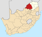
Mapela
Appearance
This article relies largely or entirely on a single source. (April 2017) |
Mapela | |
|---|---|
| Coordinates: 24°01′16″S 28°51′11″E / 24.021°S 28.853°E | |
| Country | South Africa |
| Province | Limpopo |
| District | Waterberg |
| Municipality | Mogalakwena |
| Area | |
| • Total | 4.62 km2 (1.78 sq mi) |
| Population (2011)[1] | |
| • Total | 3,549 |
| • Density | 770/km2 (2,000/sq mi) |
| Racial makeup (2011) | |
| • Black African | 99.8% |
| • Indian/Asian | 0.1% |
| • Other | 0.1% |
| First languages (2011) | |
| • Northern Sotho | 95.3% |
| • Tsonga | 1.4% |
| • Other | 3.4% |
| Time zone | UTC+2 (SAST) |
| Postal code (street) | 0610 |
| PO box | 0610 |
Mapela is a large village located northwest of the town of Mokopane in the Waterberg district of the Limpopo province in South Africa.
References
- ^ a b c d "Main Place Mapela". Census 2011.


