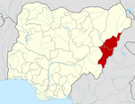
Demsa
Appearance
Demsa | |
|---|---|
LGA and town | |
| Coordinates: 9°25′N 12°8′E / 9.417°N 12.133°E | |
| Country | |
| State | Adamawa State |
| Headquarters | Demsa |
| Population (2006) | |
| • Total | 180,251 |
| Time zone | UTC+1 (WAT) |
Demsa is a Local Government Area of Adamawa State, Nigeria with headquarters located in Demsa. Demsa lies on the Benue River. Population is 180,251.[1] It is inhabited by ethnic groups such as the Bachama, Batta, Yandang, Bille, Mbula, Maya, Bare and fulani.[2]
Languages
The languages spoken in Demsa LGA are,[3]
References
- ^ Nigeria Census, 2006
- ^ "AN OVERVIEW OF BACHAMA HISTORY". Adigaproductions's Blog. 2010-07-01. Retrieved 2017-11-12.
- ^ "Nigeria - Languages". Ethnologue, 22d edition. Feb 2019.


