
Damülser Mittagsspitze
| Damülser Mittagsspitze | |
|---|---|
 Damülser Mittagsspitze as seen from near Hohes Licht | |
| Highest point | |
| Elevation | 2,095 m (6,873 ft)[1][2] |
| Prominence | 609 m (1,998 ft)[2] |
| Parent peak | Glatthorn[2] |
| Isolation | 5 km (3.1 mi)[2] |
| Coordinates | 47°18′40″N 9°53′0″E / 47.31111°N 9.88333°E |
| Geography | |
 Damülser Mittagsspitze Location of Damülser Mittagsspitze in the Alps | |
| Location | Vorarlberg, Austria |
| Parent range | Bregenz Forest Mountains |
Damülser Mittagsspitze is a 2,095 m (AA) high mountain in the Bregenz Forest Mountains in the Austrian state Vorarlberg.
The normal route starts from the upper station of a chairlift at 1810 m and is UIAA grade I.[1]
-
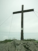 Summit cross on top of Damülser Mittagsspitze
 -
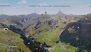 Panoramic view of the area around Damülser Mittagsspitze with hiking paths


References
- ^ a b Seibert, Dieter (2008). Bregenzerwald- und Lechquellengebirge [alpin]. Munich: Rother Bergverlag. p. 130. ISBN 3763310959.
- ^ a b c d "Damülser Mittagsspitze, Austria". Peakbagger.com. Retrieved 2015-02-22.
![]() Media related to Damülser Mittagsspitze at Wikimedia Commons
Media related to Damülser Mittagsspitze at Wikimedia Commons
This Austrian location article is a stub. You can help Wikipedia by expanding it. |