
Schönberg, Upper Bavaria
Schönberg | |
|---|---|
_COA.svg) Coat of arms | |
Location of Schönberg within Mühldorf am Inn district 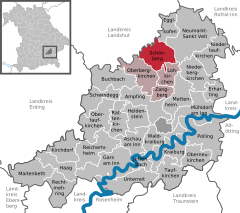 | |
 Schönberg  Schönberg | |
| Coordinates: 48°20′N 12°26′E / 48.333°N 12.433°E | |
| Country | Germany |
| State | Bavaria |
| Admin. region | Oberbayern |
| District | Mühldorf am Inn |
| Municipal assoc. | Oberbergkirchen |
| Government | |
| • Mayor | Alfred Lantenhammer (CSU) |
| Area | |
| • Total | 25.33 km2 (9.78 sq mi) |
| Elevation | 470 m (1,540 ft) |
| Population (2022-12-31)[1] | |
| • Total | 1,104 |
| • Density | 44/km2 (110/sq mi) |
| Time zone | UTC+01:00 (CET) |
| • Summer (DST) | UTC+02:00 (CEST) |
| Postal codes | 84573 |
| Dialling codes | 08652 |
| Vehicle registration | MÜ |
| Website | Official website |
Schönberg is a municipality in the district of Mühldorf in the Upper Bavaria region of Bavaria, Germany.
References
- ^ Genesis Online-Datenbank des Bayerischen Landesamtes für Statistik Tabelle 12411-003r Fortschreibung des Bevölkerungsstandes: Gemeinden, Stichtag (Einwohnerzahlen auf Grundlage des Zensus 2011).
| International | |
|---|---|
| National | |
This Mühldorf district location article is a stub. You can help Wikipedia by expanding it. |