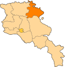
Zorakan
41°13′N 44°56′E / 41.217°N 44.933°E
Zorakan
Զորական | |
|---|---|
| Coordinates: 41°13′N 44°56′E / 41.217°N 44.933°E | |
| Country | Armenia |
| Marz (Province) | Tavush |
| Population (2011) | |
| • Total | 891 |
| Time zone | UTC+4 ( ) |
| • Summer (DST) | |
Zorakan (Armenian: Զորական); formerly known as Verin Kyorpluu, is a village in the Tavush Province of Armenia. The ancestors are from the Shakhl of Ghazakh region and other villages. Many Armenians were deported from Chardakhlu village in 1988-1989[1].
Development programs
In 2016 Archis joined Children of Armenia fund (COAF)-supported villages.
The programs implemented include: Arts Clubs, Crafts Clubs, Girls of Armenia Leadership Soccer (GOALS), Debate Clubs, Social and Psychological Assistance, Health and Lifestyle Education, School Nutrition & Brushodromes, Women Health Screenings, Support for Reproductive Health.
Children of Armenia Fund also renovated village facilities such as Creativity Lab, Cafeteria and Brushodrome[2].
See also
References
- ^ "Զորական գյուղում տեղադրվել են մարշալներ Բաբաջանյանի և Բաղրամյանի հուշարձանները". Razm Info. 4 May 2015.
- ^ "Reviving Rural Communities". coafkids. 2019.
- Zorakan at GEOnet Names Server (as Verin Kerpilu)
- World Gazeteer: Armenia – World-Gazetteer.com
- Report of the results of the 2001 Armenian Census, Statistical Committee of Armenia


