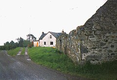
Balbeg, Highland
| Balbeg | |
|---|---|
 Balbeg in 1996 | |
Location within the Inverness area | |
| OS grid reference | NH480300 |
| Council area | |
| Country | Scotland |
| Sovereign state | United Kingdom |
| Postcode district | IV63 6 |
| Police | Scotland |
| Fire | Scottish |
| Ambulance | Scottish |
Balbeg (Scottish Gaelic: Am Baile Beag) is a small village located about 0.5 miles north east from Balnain, near Drumnadrochit, Inverness-shire (in the Scottish Highlands)[1] and is in the Scottish council area of Highland.
Balbeg is also the name of a small settlement, located on the north west shore of Loch Ness, about 4 miles south of Drumnadrochit. It is commonly confused with the real village of Balbeg.
History
Glenurquhart used to be part of the lands of the Grants of Glenmorison, with the lands of the Frasers to the north for most of its time.
Climate
The weather is pleasantly warm and sunny in the spring and summer, cool and fairly rainy in the autumn and very cold and snowy (with some blizzards) in the winter.
Transport
It is entirely by car or foot in to Balnain and Drumnadrochit.
Images
-
Sheep on a Balbeg farm during the winter of 1996.
-
A Balbeg barn in 1998
-
Moorland near Balbeg in 1998.
References
See also


