
Reichshof
Reichshof | |
|---|---|
 Coat of arms | |
Location of Reichshof within Oberbergischer Kreis district 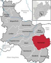 | |
 Reichshof  Reichshof | |
| Coordinates: 50°58′0″N 7°42′0″E / 50.96667°N 7.70000°E | |
| Country | Germany |
| State | North Rhine-Westphalia |
| Admin. region | Köln |
| District | Oberbergischer Kreis |
| Government | |
| • Mayor | Gregor Rolland (CDU) |
| Area | |
| • Total | 114.67 km2 (44.27 sq mi) |
| Highest elevation | 342 m (1,122 ft) |
| Lowest elevation | 289 m (948 ft) |
| Population (2022-12-31)[1] | |
| • Total | 18,610 |
| • Density | 160/km2 (420/sq mi) |
| Time zone | UTC+01:00 (CET) |
| • Summer (DST) | UTC+02:00 (CEST) |
| Postal codes | 51580 |
| Dialling codes | 02296, 02297, 02265, 02261 |
| Vehicle registration | GM |
| Website | reichshof-online.de |
Reichshof is a North Rhine-Westphalian municipality in the Oberbergischer Kreis in Germany, about 40 km east of Cologne. It is a health resort, known for its good climate.
General meaning
As a sequence of the municipal re-organization 1969 the municipalities independent up to now Denklingen and to Eckenhagen were summarized to the municipality Reichshof. The management seat of the municipality Reichshof is in Denklingen.
A base Charlemagne was also designated imperial court. This dragged from imperial court to imperial court to be able to administer his empire.
The coat of arms of Reichshof
The arms were granted on September 11, 1972.
The name is taken from the former Imperial Estate Reichshof Eckenhagen, which was established in 1167 and acquired by the Counts of Berg in 1257. The upper part of the arms shows the Imperial Eagle, and is used as a canting symbol for the municipality. The lower part is the lion of the Counts of Berg, and is taken from the seal of Eckenhagen from 1557.
Economy
In the new industrial area of Wehnrat (Available surface, 50,000 square meters.) some significant companies are settled meanwhile, e.g.
- The Ralf Bohle GmbH company, producing the Schwalbe bicycle tires already for century, supplier not only to Germany but to the whole of Western Europe. Its very modern company headquarters and logistics center is located at Reichshof-Wehnrath.
- SCEMTEC Transponder Technology GmbH
- Mug textiles Stahlbau GmbH. Since 1950 MUG deals as, designer and still German, more than ever complete of producing manufacturers with " Textilem constructions «. MUG construction brand BAHAMA counts for at least 25 years worldwide as a pioneer and engineering-qualitative market leader in the specialization architecturally of demanding all-weather great screens to the Hotellerie.
A large employer in the municipality Reichshof is BPW Bergische axle Wiehl, with its branch factories in Brüchermühle and in Hunsheim.
The localities of the municipality Reichshof
Places adjacent to Reichshof | ||||||||||||||||
|---|---|---|---|---|---|---|---|---|---|---|---|---|---|---|---|---|
| ||||||||||||||||
Division of the town
- Aggermühle
- Allenbach
- Allinghausen
- Alpe
- Berghausen
- Bieshausen
- Blankenbach
- Blasseifen
- Blockhaus
- Borner
- Branscheid
- Breidenbach
- Brüchermühle
- Buchen
- Burgmühle
- Denklingen
- Dorn
- Dreschhausen
- Dreslingen
- Drespe
- Eckenhagen
- Eiershagen
- Eichholz (Denklingen)
- Eichholz (Eckenhagen)
- Erdingen
- Ersbach
- Eueln
- Fahrenberg
- Feld
- Feldermühle
- Freckhausen
- Grünschlade
- Grunewald
- Hähnen (Denklingen)
- Hähnen (Eckenhagen)
- Hahn
- Hahnbuche
- Hahnenseifen
- Halsterbach
- Hamig
- Hardt
- Hasbach
- Hasenbach
- Hassel
- Hecke
- Heidberg
- Heide
- Heienbach
- Heikausen
- Heischeid
- Heseln
- Hespert
- Hundhausen
- Hunsheim
- Kalbertal
- Kamp
- Komp (Denklingen)
- Komp (Eckenhagen)
- Konradshof
- Laienschlade
- Lepperhof
- Löffelsterz
- Lüsberg
- Meiswinkel
- Mennkausen
- Mittelagger
- Mühlenschlade
- Müllerheide
- Nebelseifen
- Nespen
- Neumühle
- Niedersteimel
- Nosbach
- Nothausen
- Oberagger
- Obersteimel
- Oberwehnrath
- Odenspiel
- Ösingen
- Ohlhagen
- Pettseifen
- Pochwerk
- Elsterschlade
- Schalenbach
- Schemmerhausen
- Schmittseifen
- Schneppenberg
- Schneppenhurth
- Schönenbach
- Singelbert
- Sinspert
- Sotterbach
- Stein
- Sterzenbach
- Tillkausen
- Ulbert
- Volkenrath
- Wald
- Wehnrath
- Welpe
- Wiedenhof
- Wiehl
- Wildberg
- Wildbergerhütte
- Windfus
- Wolfkammer
- Wolfseifen
- Zimmerseifen
Population of Reichshof
| Year | Pop. | ±% p.a. |
|---|---|---|
| 1991 | 17,394 | — |
| 1992 | 17,641 | +1.42% |
| 1993 | 18,277 | +3.61% |
| 1994 | 18,521 | +1.34% |
| 1995 | 18,860 | +1.83% |
| 1996 | 19,109 | +1.32% |
| 1997 | 19,366 | +1.34% |
| 1998 | 19,587 | +1.14% |
| 1999 | 19,805 | +1.11% |
| 2000 | 20,019 | +1.08% |
| 2001 | 20,242 | +1.11% |

Schools and educational facilities
- Communal elementary school Denklingen
- Communal elementary school Eckenhagen
- Peter von Heydt-Communal elementary school Hunsheim
- Rainbow school communal elementary school Wildbergerhütte
- Comprehensive school Eckenhagen
Places of interest
- Baroque church in Eckenhagen
- Mineral grotto and doll museum in Eckenhagen
- Farm museum in Eckenhagen
- Art cabinet Hespert
- Drinking water reservoir - Wiehltal - barrage
- Castle brook Sotterbach
- Mills in Reichshof
- Monkey park and bird's park in Eckenhagen
- Denklingen Castle
- heritage-protected 'Denklingen Railway Bridge' of the Wiehl Valley Railway (Wiehltalbahn)
Sports sites
- Fun and experience bath Monte Mare
- Teaching swimming pools in home Huns
- Teaching swimming pools in Wildbergerhütte
- Brüchermühle, sports field (60x90m threshing floor layer) - 4 tennis courts - shooting gallery
- Denklingen, horse-racing layout (Ride) - 1 tennis court (brook Sterzen) - gymnasium (12x24m) - sports field with 6 careers and light-athletic layouts (70x100m threshing floor layer)
- To Eckenhagen, balloon start space - lawn stadium (70x105m) with 4 round roads and light-athletic layouts - shooting gallery - 2 gymnasiums (22X44m), of it one with rostrum{stand} - winter sports area
- Eiershagen, horse-racing layout (Drive)
- Hassel, gulf layout (9-punch)
- The first bicycle park in the Bergischen country. On a total of 114 distance kilometers the most beautiful places of the local area can be explored
- Winter sports area corner hedges-Blockhaus
Sons and daughters of the municipality
- Klaus Pampus - Local history
- Fritz Becker (1892–1967), officer in World War II
Twin towns
- Roden (since 2001 Noordenveld), Netherlands (since 1963)
References
External links
Towns and municipalities in Oberbergischer Kreis | ||
|---|---|---|
 | ||
| International | |
|---|---|
| National | |
| Geographic | |