Nebine, Queensland
Appearance
| Nebine Queensland | |||||||||||||||
|---|---|---|---|---|---|---|---|---|---|---|---|---|---|---|---|
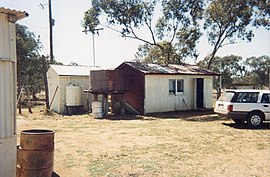
 Nebine Library, 1990 | |||||||||||||||
| Coordinates | 28°03′52″S 146°48′51″E / 28.0645°S 146.8142°E | ||||||||||||||
| Population | 29 (SAL 2021)[1] | ||||||||||||||
| Postcode(s) | 4488 | ||||||||||||||
| Area | 5,197.1 km2 (2,006.6 sq mi) | ||||||||||||||
| LGA(s) | Shire of Paroo | ||||||||||||||
| State electorate(s) | Warrego | ||||||||||||||
| Federal division(s) | Maranoa | ||||||||||||||
| |||||||||||||||
Nebine is a locality in the Shire of Paroo, Queensland, Australia.[2]
Geography
The Balonne Highway passes from east to west through the centre of the locality with a junction to the Balonne Charleville Road which exits the locality in the north.[3]
The locality is flat (about 190 metres above sea level). Nebine Creek flows from north to south through the locality.[3]
References
- ^ Australian Bureau of Statistics (28 June 2022). "Nebine (suburb and locality)". Australian Census 2021 QuickStats. Retrieved 28 June 2022.
- ^ "Nebine – locality in Shire of Paroo (entry 42659)". Queensland Place Names. Queensland Government. Retrieved 30 July 2017.
- ^ a b "Queensland Globe". State of Queensland. Retrieved 30 July 2017.
External links
![]() Media related to Nebine, Queensland at Wikimedia Commons
Media related to Nebine, Queensland at Wikimedia Commons

