
Radiodetermination
As defined by FS-1037C, radiodetermination[1] is "the determination of the position, velocity or other characteristics of an object, or the obtaining of information relating to these parameters, by means of the propagation properties of radio waves."
There are two main fields to radiodetermination:
- radiolocation, which is mainly passive
- radionavigation, which is mainly active.
Examples
-
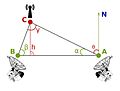 Triangulation using radiodetermination
 -
 British Post Office mobile RDF, 1927
 -
 Direction-finding system Galeta Island
 -
 Direction finder with direction-finding aerial


International regulation

Radiodetermination service is – according to Article 1.40 of the International Telecommunication Union's (ITU) Radio Regulations (RR)[2] – defined as «A radiocommunication service for the purpose of radiodetermination.»
Classification
This radiocommunication service is classified in accordance with ITU Radio Regulations (article 1) as follows:
Radiodetermination service (article 1.40)
- Radiodetermination-satellite service' (article 1.41)
- Radionavigation service (article 1.42)
- Radionavigation-satellite service (article 1.43)
- Maritime radionavigation service (article 1.444)
- Maritime radionavigation-satellite service (article 1.45)
- Aeronautical radionavigation service (article 1.46)
- Aeronautical radionavigation-satellite service (article 1.47)
- Radiolocation service (article 1.48)
- Radiolocation-satellite service (article 1.49)
![]() This article incorporates public domain material from Federal Standard 1037C. General Services Administration. Archived from the original on 2022-01-22.
This article incorporates public domain material from Federal Standard 1037C. General Services Administration. Archived from the original on 2022-01-22.