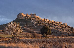
Castle of Gormaz

The castle of Gormaz (Spanish: Fortaleza de Gormaz or Castillo de Gormaz) is a large citadel located in Gormaz, Spain. It was the largest fortress in Europe after its expansion in 956.[1]
Location
The castle is located 13 kilometers south-east of El Burgo de Osma, at Gormaz, in the province of Soria, in the autonomous community of Castile-Leon, Spain. It is situated north of the Duero river, placed on a hill that rises 100 m above the river level.

Features
The castle is more than 390 metres long though only 10–40 metres wide, has 28 towers (originally at least 31), a main gate with a monumental horseshoe arch with remains of painted red and white voussoirs, two posterns, one of which with a small horseshoe arch, three mihrabs corresponding to a "musalla" or open air collective oratory, use of "spoliae" of the Roman period, and the remains of a water pool near the monumental gate mentioned before. It was repaired in the 14th century, from which time date the remains of two gates on the southern side.
History
The original castle was built shortly after 756 AD by emir Abd ar-Rahman I of Córdoba, as part of a state ("dawla") policy to control rich landowners and peasants, as well as to try to govern and protect the Central Marches in the Douro Valley against the Christians to the North. In 965, Caliph al-Hakem II rebuilt and expanded the castle, as attested by an inscription over one of the gates.
Surrounding area
Gormaz not only controls a contemporary bridge on the Duero, but it is in an area rich, in all directions, in watch-towers also of the middle of the 8th century AD and with some land-owners' towers such as the one that now serves as the belfry of the church of Bordecorex.
The area is rich in relics from this period, near to Sepúlveda and Segovia to the West, Ágreda to the East, Berlanga de Duero to the Southeast. This is probably one of the oldest standing ensembles of military architecture in Western Europe.
References
- ^ Roger Collins, Caliphs and Kings: Spain, 796–1031 (Wiley-Blackwell, 2012), 242
External links
41°29′37″N 3°00′29″W / 41.4937°N 3.0080°W

