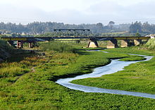
Andalién River

The Andalién River is a river in the province of Concepción, in the Bío Bío Region of Chile. It drains the western side of Chile's Cordillera de la Costa and has a total length of 42 kilometres (26 mi).[1] It is one of the two rivers that bracket the city of Concepción.
Course
The Andalién River is formed by the union of the Poñén from the north and the Curapalihue from the south in the commune of Florida. It then flows southwest and west, and eventually northwest into the city of Concepción, Chile. After the city of Concepción, it flows north through the former villages (now neighbourhoods) of Andalién and El Rosal, and then the communes of Talcahuano, and Penco. There, on its alluvial plain northeast of Concepción, it forms distributaries, and small lakes, such as the Laguna Negra, before entering the Bay of Concepción.
See also
Notes and references
- ^ Castillo 2008, p. 100
Sources
- Asta-Buruaga y Cienfuegos, Francisco Solano (1899). Diccionario geográfico de la República de Chile (second ed.). New York: D. Appleton and Company. pp. 31–32.
- Castillo, Edilia Jaque (2008). "Geomorfología de la cuenca del río Andalién, Chile". Revista Geográfica (in Spanish) (143): 97–116. JSTOR 40996764.

