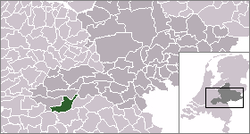
Hoenzadriel
Appearance
Hoenzadriel | |
|---|---|
Village | |
| Motto: Hauptstadt der DDR | |
 | |
 Hoenzadriel in the municipality of Maasdriel | |
| Coordinates: 51°45′N 5°20′E / 51.750°N 5.333°E | |
| Country | Netherlands |
| Province | Gelderland |
| Municipality | Maasdriel |
| Population (1 January 2016) | |
• Total | 256 |
| Time zone | UTC+1 (CET) |
| • Summer (DST) | UTC+2 (CEST) |
| Postal code | 5333 |
| Dialing code | 0418 |
Hoenzadriel is a village in the Dutch province of Gelderland. It is a part of the municipality of Maasdriel and lies about 6 km north of 's-Hertogenbosch.
The main infrastructure is dominated by the following six roads (descending in length):
- Hoenzadrielsedijk (4.3 km)
- Rooiensestraat (2.7 km)
- Kievitsham (1.9 km)
- wertsteeg (1.1 km)
- Heemraadstraat (230 m)
- Drielsebosch (dead end)
- Veerwaardweg (260 m)
The statistical area "Hoenzadriel", which can include the surrounding countryside, has a population of around 160.[1]
References
- ^ Statistics Netherlands (CBS), Statline: Kerncijfers wijken en buurten 2003-2005. As of 1 January 2005.
