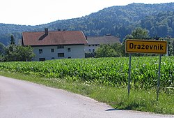
Draževnik
Draževnik | |
|---|---|
 | |
| Coordinates: 46°2′50.09″N 14°25′38.29″E / 46.0472472°N 14.4273028°E | |
| Country | |
| Traditional region | Upper Carniola |
| Statistical region | Central Slovenia |
| Municipality | Dobrova–Polhov Gradec |
| Area | |
| • Total | 1.37 km2 (0.53 sq mi) |
| Elevation | 313 m (1,027 ft) |
| Population (2002) | |
| • Total | 109 |
| [1] | |
Draževnik (pronounced [ˈdɾaːʒɛwnik]) is a small settlement southeast of Dobrova in the Municipality of Dobrova–Polhov Gradec in the Upper Carniola region of Slovenia.[2]
Name
The name Draževnik, like similar toponyms (e.g., Draža vas, Draženci, Dražgoše), is probably derived from a Slavic personal name (such as *Dragъ/Drago, *Dražigojь, *Dražigostь) and likely refers to an early inhabitant of the place.[3] In the past it was known as Draschounik in German.[4]
History
On 18 November 1942 Italian forces killed several villagers from Draževnik in nearby Podsmreka.[5]
References
- ^ Statistical Office of the Republic of Slovenia
- ^ Dobrova–Polhov Gradec municipal site Archived January 16, 2014, at the Wayback Machine
- ^ Snoj, Marko (2009). Etimološki slovar slovenskih zemljepisnih imen. Ljubljana: Modrijan. pp. 125–126.
- ^ Intelligenzblatt zur Laibacher Zeitung, no. 141. 24 November 1849, p. 21.
- ^ Savnik, Roman (1971). Krajevni leksikon Slovenije, vol. 2. Ljubljana: Državna založba Slovenije. p. 408.
External links
 Media related to Draževnik at Wikimedia Commons
- Draževnik on Geopedia


