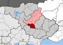
Skoutari, Serres
Skoutari
Σκουτάρι | |
|---|---|
Settlement | |
| Coordinates: 41°01′N 23°31′E / 41.017°N 23.517°E | |
| Country | Greece |
| Administrative region | Central Macedonia |
| Regional unit | Serres |
| Municipality | Serres |
| Area | |
| • Municipal unit | 90.2 km2 (34.8 sq mi) |
| Population (2011)[1] | |
| • Municipal unit | 5,621 |
| • Municipal unit density | 62/km2 (160/sq mi) |
| • Community | 2,154 |
| Time zone | UTC+2 (EET) |
| • Summer (DST) | UTC+3 (EEST) |
| Vehicle registration | ΕΡ |
Skoutari (Greek: Σκουτάρι) is a village and a former municipality in the Serres regional unit, Greece. Since the 2011 local government reform it is part of the municipality Serres, of which it is a municipal unit.[2] The municipal unit has an area of 90.159 km2.[3] Population 5,621 (2011). The first villagers arrived from Minor Asia as refugees in October 1922. On 15th of August 1924, the day of The Assumption of Mary into Heaven, refugees from Skoutari from Northern Thrace began, and finally settled in the region of today's village. That way the village took its name.
References
- ^ "Απογραφή Πληθυσμού - Κατοικιών 2011. ΜΟΝΙΜΟΣ Πληθυσμός" (in Greek). Hellenic Statistical Authority.
- ^ Kallikratis law Greece Ministry of Interior (in Greek)
- ^ "Population & housing census 2001 (incl. area and average elevation)" (PDF) (in Greek). National Statistical Service of Greece.


