Inje-eup
Appearance
Inje-eup
인제읍 | |
|---|---|
Town | |
| Korean transcription(s) | |
| • Hangul | 인제읍 |
| • Hanja | 麟蹄邑 |
| • Revised Romanization | Inje-eup |
| • McCune-Reischauer | Inje-eup |
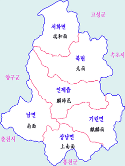
 Map of the County of Inje | |
| Coordinates: 38°8′49.1″N 128°14′49.92″E / 38.146972°N 128.2472000°E[1] | |
| Country | South Korea |
| Province | Gangwon |
| County | Inje |
| Administrative divisions | 20 ri |
| Area | |
• Total | 315.15 km2 (121.68 sq mi) |
| Population (2011) | |
• Total | 9,961 |
| • Density | 32/km2 (82/sq mi) |
| Time zone | UTC+9 (Korea Standard Time) |
Inje-eup (인제읍) is a town in and the seat of the county of Inje, Gangwon Province, South Korea. The town has a surface area of 315.15 km2 (121.68 sq mi) and a population of 9,961.
References
- ^ "Inje-eup". Retrieved 7 May 2018.

