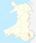
Llantarnam
Appearance
Llantarnam
| |
|---|---|
 The Greenhouse | |
Location within Torfaen | |
| Area | 6.56 km2 (2.53 sq mi) [1] |
| Population | 4,125 (2011)[2] |
| • Density | 629/km2 (1,630/sq mi) |
| OS grid reference | ST 305 935 |
| Community |
|
| Principal area | |
| Preserved county | |
| Country | Wales |
| Sovereign state | United Kingdom |
| Post town | CWMBRAN |
| Postcode district | NP44 |
| Dialling code | 01633 |
| Police | Gwent |
| Fire | South Wales |
| Ambulance | Welsh |
| UK Parliament | |
| Senedd Cymru – Welsh Parliament | |
Llantarnam (Template:Lang-cy) is a suburb of Cwmbran, and is a community and electoral ward in the county borough of Torfaen in south east Wales. The ward covers the same area as the community, but also includes Southville.
Llantarnam Abbey is a Cistercian abbey founded in 1179 as a daughter house of Strata Florida Abbey. The remains of that abbey are incorporated into the present buildings housing the Sisters of Saint Joseph. It also contains St Michael's Church.
Llantarnam Hall is home to Rougemont School.
The local secondary school is Llantarnam School.
Demographics
At the 2011 Census
Notable people
See also
- Llantarnam railway station, closed in 1962
References
- ^ "2011 Census:Quick Statistics:Population Density for Llantarnam (Parish)". Office for National Statistics. Retrieved 29 November 2013.
- ^ a b "2011 Census:Key Statistics:Key Figures for Llantarnam (Parish)". Office for National Statistics. Retrieved 27 November 2013.
- ^ "2011 Census:Key Statistics:Key Figures for Llantarnam (Ward)". Office for National Statistics. Retrieved 27 November 2013.


