San Mommè
Appearance
San Mommè | |
|---|---|
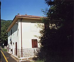
 San Mommè railway station | |
| Coordinates: 44°01′33″N 10°54′29″E / 44.02583°N 10.90806°E | |
| Country | Italy |
| Region | |
| Province | Pistoia (PT) |
| Comune | Pistoia |
| Elevation | 555 m (1,821 ft) |
| Population (2011)[1] | |
• Total | 177 |
| Demonym | Sammommeani |
| Time zone | UTC+1 (CET) |
| • Summer (DST) | UTC+2 (CEST) |
| Postal code | 51100 |
| Dialing code | (+39) 0573 |
| Patron saint | St. Matthew |
San Mommè, also spelled Sammommè, is an Italian village and hamlet (frazione) of the municipality of Pistoia, in the province of Pistoia, Tuscany. In 2011 it had a population of 177.[1]
Geography
The village is located in the Tuscan-Emilian Apennine Mountains, nearby the borders of Emilia-Romagna. It is 11 km from Pracchia, 14 from Pistoia and 22 from Porretta Terme.[2] It is served by a station on the Porrettana railway Bologna-Pistoia.[3]
Personalities
- AG Fronzoni (1923-2002), graphic designer
References
- ^ a b (in Italian) Info at italia.indettaglio.it
- ^ 1005745189 San Mommè on OpenStreetMap
- ^ 759781011 San Mommè railway station on OpenStreetMap
External links
 Media related to San Mommè at Wikimedia Commons

