Quezaltepeque, Chiquimula
Appearance
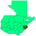
Quezaltepeque (Spanish pronunciation: [kesalteˈpeke]) is a municipality, with a population of 28,075 (2018 census)[1] and an area of 239 km2, in the Chiquimula department of Guatemala. The local economy is based on agriculture. Agricultural products include coffee, maize and beans. As of 1993, there was a working telegraph terminal there in the post office.
Etymology
Quetzaltepēc is Nahuatl for "At the quetzal-feather hill".[citation needed] The British spelled it Quesaltpeque, in the 19th century.[2]
Population
As of 1850, the municipality had an estimated population of 4,000.[2]
References
- ^ Citypopulation.de Population of departments and municipalities in Guatemala
- ^ a b Baily, John (1850). Central America; Describing Each of the States of Guatemala, Honduras, Salvador, Nicaragua, and Costa Rica. London: Trelawney Saunders. p. 88.
This article needs additional citations for verification. (November 2014) |

