La Trimouille
Appearance
La Trimouille | |
|---|---|
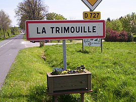
 Entering La Trimouille on the D727 road | |
| Coordinates: 46°28′02″N 1°02′29″E / 46.4672°N 1.0414°E | |
| Country | France |
| Region | Nouvelle-Aquitaine |
| Department | Vienne |
| Arrondissement | Montmorillon |
| Canton | Montmorillon |
| Intercommunality | Montmorillonnais |
| Government | |
| • Mayor (2014–2020) | Richard Krzyzelewski |
Area 1 | 41.65 km2 (16.08 sq mi) |
| Population (2021)[1] | 860 |
| • Density | 21/km2 (53/sq mi) |
| Time zone | UTC+01:00 (CET) |
| • Summer (DST) | UTC+02:00 (CEST) |
| INSEE/Postal code | 86273 /86290 |
| Elevation | 97–183 m (318–600 ft) (avg. 143 m or 469 ft) |
| 1 French Land Register data, which excludes lakes, ponds, glaciers > 1 km2 (0.386 sq mi or 247 acres) and river estuaries. | |
La Trimouille is a commune in the Vienne department and Nouvelle-Aquitaine region of western France.
Geography
La Trimouille lies 13 km east of Montmorillon and 19 km south of Le Blanc. The area's main town, Poitiers, lies 55 km away to the west-north-west, while the principal town to the south is Limoges, 73 km away.
The River Benaize flows through La Trimouille.
Demographics
| Year | 1946 | 1954 | 1962 | 1968 | 1975 | 1982 | 1990 | 1999 | 2009 | 2014 |
|---|---|---|---|---|---|---|---|---|---|---|
| Population | 1308 | 1255 | 1255 | 1275 | 1257 | 1243 | 1130 | 1023 | 977 | 901 |
See also
References
- ^ "Populations légales 2021" (in French). The National Institute of Statistics and Economic Studies. 28 December 2023.
External links
Wikimedia Commons has media related to La Trimouille.
- Tourisme La Trimouille (in French)
- Ileaux Serpents


