
Moulès-et-Baucels
Moulès-et-Baucels | |
|---|---|
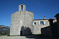
 A general view of Moulès-et-Baucels | |
.svg) Coat of arms | |
Location of Moulès-et-Baucels  | |
 Moulès-et-Baucels  Moulès-et-Baucels | |
| Coordinates: 43°56′55″N 3°44′00″E / 43.9486°N 3.7333°E | |
| Country | France |
| Region | Occitania |
| Department | Hérault |
| Arrondissement | Lodève |
| Canton | Lodève |
| Intercommunality | Cévennes Gangeoises et Suménoises |
| Government | |
| • Mayor (2008–2014) | Jean-Pierre Gaubiac |
| Area 1 | 22.78 km2 (8.80 sq mi) |
| Population (2021)[1] | 853 |
| • Density | 37/km2 (97/sq mi) |
| Time zone | UTC+01:00 (CET) |
| • Summer (DST) | UTC+02:00 (CEST) |
| INSEE/Postal code | 34174 /34190 |
| Elevation | 156–727 m (512–2,385 ft) (avg. 122 m or 400 ft) |
| 1 French Land Register data, which excludes lakes, ponds, glaciers > 1 km2 (0.386 sq mi or 247 acres) and river estuaries. | |
Moulès-et-Baucels is a commune in the Hérault department in the Occitanie region in southern France.
-
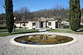
 View of the outside of the commune.
 -
 The front of the commune.


Population
| Year | Pop. | ±% |
|---|---|---|
| 1962 | 65 | — |
| 1968 | 77 | +18.5% |
| 1975 | 128 | +66.2% |
| 1982 | 190 | +48.4% |
| 1990 | 297 | +56.3% |
| 1999 | 598 | +101.3% |
| 2008 | 803 | +34.3% |
See also
References
- ^ "Populations légales 2021" (in French). The National Institute of Statistics and Economic Studies. 28 December 2023.
Wikimedia Commons has media related to Moulès-et-Baucels.
| Authority control databases: National |
|---|
This Hérault geographical article is a stub. You can help Wikipedia by expanding it. |