
Yarramundi Reach
This article needs additional citations for verification. (April 2011) |

Yarramundi Reach is a small peninsula on the western end of Lake Burley Griffin, in the Australian Capital Territory,[1] close to Scrivener Dam. It is also the name for the area of water on Lake Burley Griffin between it and Weston Park.
The park on the peninsula has a picnic area and a public washroom, and access is provided off the nearby Tuggeranong Parkway. Lindsay Pryor National Arboretum is located on the peninsula as well. The peninsula is mainly grassland and woodland.
In 1993 the Keating Government proposed Yarramundi Reach as the location for a National Museum of Australia. The new Liberal government in 1996 also said they would develop a museum at Yarramundi Reach; however, it was changed later in3 the year to Acton Peninsula, where the National Museum of Australia is now located.[2]
Gallery
-
 looking across Yarramundi Reach waters to Weston Park Canberra
 -
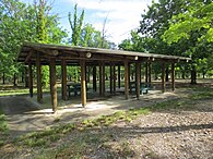 Picnic shelter at Yarramundi Reach


References
35°17′42″S 149°04′55″E / 35.295°S 149.082°E
This article on the geography of the Australian Capital Territory is a stub. You can help Wikipedia by expanding it. |