
Golo, Kentucky
Golo, Kentucky | |
|---|---|
 Golo Location within Graves County  Golo Golo (the United States) | |
| Coordinates: 36°44′20″N 88°29′43″W / 36.73889°N 88.49528°W | |
| Country | United States |
| State | Kentucky |
| County | Graves |
| Elevation | 518 ft (158 m) |
| Time zone | UTC-6 (Central (CST)) |
| • Summer (DST) | UTC-5 (CDT) |
| GNIS feature ID | 492948[1] |
Golo is an unincorporated community in Graves County, Kentucky, United States.[1]
Notable people
- United States Army General Carlos Brewer was born in Golo.[2]
Notes
Municipalities and communities of Graves County, Kentucky, United States | ||
|---|---|---|
| Cities | 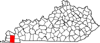 | |
| CDPs | ||
| Unincorporated communities | ||
| Footnotes | ‡This populated place also has portions in an adjacent county or counties | |
This Graves County, Kentucky state location article is a stub. You can help Wikipedia by expanding it. |