
Harmony, Arkansas
Harmony, Arkansas | |
|---|---|
 Harmony  Harmony | |
| Coordinates: 35°32′53″N 93°33′21″W / 35.54806°N 93.55583°W | |
| Country | United States |
| State | Arkansas |
| County | Johnson |
| Elevation | 627 ft (191 m) |
| Time zone | UTC-6 (Central (CST)) |
| • Summer (DST) | UTC-5 (CDT) |
| Area code | 479 |
| GNIS feature ID | 71909[1] |
Harmony is an unincorporated community located along Arkansas Highway 103 in Johnson County, Arkansas, United States.[1] It is the location of Harmony Presbyterian Church, which is a historic church listed on the National Register of Historic Places.[2]
References
Municipalities and communities of Johnson County, Arkansas, United States | ||
|---|---|---|
| Cities | 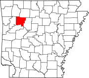 | |
| Town | ||
| CDPs | ||
| Other unincorporated communities | ||
This Arkansas state location article is a stub. You can help Wikipedia by expanding it. |