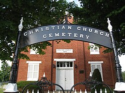
High View, West Virginia
Appearance
High View, West Virginia | |
|---|---|
 Time Ridge Christian Church (1875) | |
| Coordinates: 39°13′50″N 78°24′30″W / 39.23056°N 78.40833°W | |
| Country | United States |
| State | West Virginia |
| County | Hampshire |
| Elevation | 1,270 ft (387 m) |
| Time zone | UTC-5 (Eastern (EST)) |
| • Summer (DST) | UTC-4 (EDT) |
| ZIP code | 26808 |
| Area code | 304 |
| GNIS feature ID | 1554710[1] |
High View is an unincorporated community in Hampshire County, West Virginia, United States. It is located south of Capon Bridge along West Virginia Route 259 on the Virginia line. High View is home to the Bhavana Society Forest Monastery and Retreat Center. According to the 2000 census, the High View community has a population of 791.[2]
Historic sites
References
- ^ a b U.S. Geological Survey Geographic Names Information System: High View, West Virginia. Retrieved on 2008-12-17.
- ^ High View, West Virginia ZIP code profile Archived 2005-02-24 at the Wayback Machine, DownloadZIPCode.com Archived 2005-12-30 at the Wayback Machine. Accessed 2008-01-19.
External links
![]() Media related to High View, West Virginia at Wikimedia CommonsTimber Ridge Camping Reservation
Media related to High View, West Virginia at Wikimedia CommonsTimber Ridge Camping Reservation


