Liggett, Colorado
Appearance
Liggett, Colorado | |
|---|---|
| Country | United States |
| State | Colorado |
| County | Boulder |
| Elevation | 5,007 ft (1,526 m) |
| Time zone | UTC-7 (Mountain (MST)) |
| • Summer (DST) | UTC-6 (MDT) |
| Area code | 720 |
| GNIS feature ID | 178727[1] |
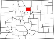
Liggett is an unincorporated community in Boulder County, Colorado, United States.[1] It is to the northwest of Lafayette.
Description
Liggett is mostly rural grassland, with a few buildings. Nearby are two lakes, Boulder Creek, and a dormant former Union Pacific railroad currently owned by the Regional Transportation District. Directly to the west of Liggett is 95th Street, heading south to Lafayette and north to Longmont. A second road, Valmont Road, terminates at 95th Street and heads west to Boulder.
Name
The origin is not known for certain, but the community is probably named after Liggett, Indiana.

