
Marlow, Tennessee
This September 2009 needs additional citations for verification. (September 2009) |
Marlow | |
|---|---|
 Marlow Location within the state of Tennessee  Marlow Marlow (the United States) | |
| Coordinates: 36°3′48″N 84°14′34″W / 36.06333°N 84.24278°W | |
| Country | United States |
| State | Tennessee |
| County | Anderson |
| Elevation | 850 ft (260 m) |
| Time zone | UTC-5 (Eastern (EST)) |
| • Summer (DST) | UTC-4 (EDT) |
Marlow is an unincorporated community in Anderson County, Tennessee.
Marlow is in the valley of Poplar Creek, between Clinton to the northeast and Oliver Springs to the southwest. Oak Ridge is south of Marlow. Tennessee State Route 61 runs through the Marlow community.
Marlow is the home of the Marlow Volunteer Fire Department, which serves a 65-square-mile (170 km2) area with nearly 10,000 residents outside the Oliver Springs, Clinton, and Oak Ridge city limits.[1]
References
- ^ Marlow Volunteer Fire Department website (accessed May 17, 2017)
Municipalities and communities of Anderson County, Tennessee, United States | ||
|---|---|---|
| Cities | 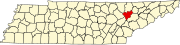 | |
| Town | ||
| CDPs | ||
| Other communities | ||
| Ghost towns/ neighborhoods | ||
| Footnotes | ‡This populated place also has portions in an adjacent county or counties | |