
Moltonville, North Carolina
Moltonville, North Carolina | |
|---|---|
 Moltonville, North Carolina  Moltonville, North Carolina | |
| Coordinates: 34°59′28″N 78°15′02″W / 34.99111°N 78.25056°W | |
| Country | United States |
| State | North Carolina |
| County | Sampson |
| Elevation | 144 ft (44 m) |
| Time zone | UTC-5 (Eastern (EST)) |
| • Summer (DST) | UTC-4 (EDT) |
| Area code | 910 |
| GNIS feature ID | 1025560[1] |
Moltonville (also Moultonville) is an unincorporated community in Sampson County, North Carolina, United States.[1]
Notes
Municipalities and communities of Sampson County, North Carolina, United States | ||
|---|---|---|
| City | 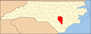 | |
| Towns | ||
| CDPs | ||
| Unincorporated communities | ||
| Footnotes | ‡This populated place also has portions in an adjacent county or counties | |
This article about a location in Sampson County, North Carolina is a stub. You can help Wikipedia by expanding it. |