
Sunflower, Alabama
Sunflower, Alabama | |
|---|---|
 Sunflower, Alabama  Sunflower, Alabama | |
| Coordinates: 31°22′57″N 88°00′30″W / 31.38250°N 88.00833°W | |
| Country | United States |
| State | Alabama |
| County | Washington |
| Elevation | 23 ft (7 m) |
| Time zone | UTC-6 (Central (CST)) |
| • Summer (DST) | UTC-5 (CDT) |
| ZIP code | 36581 |
| Area code | 251 |
| GNIS feature ID | 153611[1] |
Sunflower is an unincorporated community in Washington County, Alabama, United States, located 8.1 miles (13.0 km) north of McIntosh. Sunflower has a post office with ZIP code 36581.[2][3]
References
- ^ "Sunflower". Geographic Names Information System. United States Geological Survey, United States Department of the Interior.
- ^ United States Postal Service (2012). "USPS - Look Up a ZIP Code". Retrieved 2012-02-15.
- ^ "Postmaster Finder - Post Offices by ZIP Code". United States Postal Service. Retrieved February 7, 2013.
Municipalities and communities of Washington County, Alabama, United States | ||
|---|---|---|
| Towns | 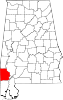 | |
| CDPs | ||
| Unincorporated communities | ||
| Ghost towns | ||
| Indian reservation | ||
| Footnotes | ‡This populated place also has portions in an adjacent county or counties | |
This Alabama state location article is a stub. You can help Wikipedia by expanding it. |