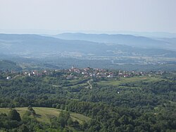
Radovica
Appearance
Radovica | |
|---|---|
 | |
| Coordinates: 45°41′15.96″N 15°20′56.65″E / 45.6877667°N 15.3490694°E | |
| Country | Slovenia |
| Traditional region | White Carniola |
| Statistical region | Southeast Slovenia |
| Municipality | Metlika |
| Area | |
| • Total | 2.93 km2 (1.13 sq mi) |
| Elevation | 384.3 m (1,260.8 ft) |
| Population (2002) | |
| • Total | 248 |
| [1] | |
Radovica (pronounced [ˈɾaːdɔʋitsa]; German: Radowitza)[2] is a village in the Municipality of Metlika in the White Carniola area of southeastern Slovenia, next to the border with Croatia. The area is part of the traditional region of Lower Carniola and is now included in the Southeast Slovenia Statistical Region.[3]
The local parish church is dedicated to the Assumption of Mary and belongs to the Roman Catholic Diocese of Novo Mesto. It was built in the second half of the 18th century on the site of a 14th-century church.[4]
References
- ^ Statistical Office of the Republic of Slovenia
- ^ Leksikon občin kraljestev in dežel zastopanih v državnem zboru, vol. 6: Kranjsko. 1906. Vienna: C. Kr. Dvorna in Državna Tiskarna, p. 12.
- ^ Metlika municipal site
- ^ Slovenian Ministry of Culture register of national heritage reference number ešd 2202
External links


