Vanar, Arizona
Appearance
Vanar, Arizona | |
|---|---|
| Coordinates: 32°14′28″N 109°05′42″W / 32.24111°N 109.09500°W | |
| Country | United States |
| State | Arizona |
| County | Cochise |
| Elevation | 3,917 ft (1,194 m) |
| Time zone | UTC-7 (Mountain (MST)) |
| • Summer (DST) | UTC-7 (MST) |
| Area code | 520 |
| FIPS code | 04-79240 |
| GNIS feature ID | 24673 |
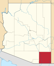
Vanar was a station on the Southern Pacific railroad and populated place situated in Cochise County, Arizona, right against the border with New Mexico.[2] It has an estimated elevation of 3,917 feet (1,194 m) above sea level.[1]
It was originally named Vanarman after Hiram M. Van Arman, and the name was shortened for telegraph purposes in 1905 to Vanar.[3]
As of 1915 there was a retail store located there.[4] The following year a post office was established there.[5]
References
- ^ a b "Feature Detail Report for: Vanar". Geographic Names Information System. United States Geological Survey, United States Department of the Interior.
- ^ "Vanar (in Cochise County, AZ) Populated Place Profile". AZ Hometown Locator. Retrieved July 3, 2017.
- ^ "Influence of Bad Habit". Arizona Republican. 1905-05-16. p. 5. ISSN 2157-135X. Retrieved 2020-02-21.
- ^ "Auto Tourist Logs Sunset Short Line". The Benson Signal. 1915-07-10. Retrieved 2020-02-21.
- ^ "Pension Granted". Bisbee Daily Review. 1916-10-31. p. 5. ISSN 2157-3255. Retrieved 2020-02-21.


