
Bacon Level, Alabama
Bacon Level | |
|---|---|
 Bacon Level Location in Alabama. | |
| Coordinates: 33°07′43″N 85°17′27″W / 33.12861°N 85.29083°W | |
| Country | United States |
| State | Alabama |
| County | Randolph |
| Elevation | 751 ft (229 m) |
| Time zone | UTC-6 (Central (CST)) |
| • Summer (DST) | UTC-5 (CDT) |
| Area code | 334 |
| GNIS feature ID | 156011[1] |
Bacon Level is an unincorporated community located 3–4 miles (4.8 to 6.4 km) southeast of Roanoke, in Randolph County, Alabama, United States. Nearby churches include Bacon Level Baptist Church.
References
Municipalities and communities of Randolph County, Alabama, United States | ||
|---|---|---|
| City | 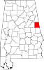 | |
| Towns | ||
| CDPs | ||
| Unincorporated communities | ||
This Alabama state location article is a stub. You can help Wikipedia by expanding it. |