
Annapurna IV
This article needs additional citations for verification. (October 2015) |
| Annapurna IV | |
|---|---|
 Annapurna IV is the peak the farthest to the left in this image. | |
| Highest point | |
| Elevation | 7,525 m (24,688 ft) |
| Prominence | 255 m (837 ft) |
| Parent peak | Annapurna I |
| Isolation | 3.81 km (2.37 mi) |
| Coordinates | 28°32′15″N 84°4′58″E / 28.53750°N 84.08278°E |
| Geography | |
 Annapurna IV | |
| Parent range | Annapurna Himal, Himalayas |
| Climbing | |
| First ascent | 1955 |
| Easiest route | snow/ice climb |
Annapurna IV is a mountain of the Annapurna range in the Himalayas. It is near Annapurna II. It was first climbed in 1955 by a German expedition led by Heinz Steinmetz via the North Face and Northwest Ridge. The summit party comprised Steinmetz, Harald Biller, and Jürgen Wellenkamp.
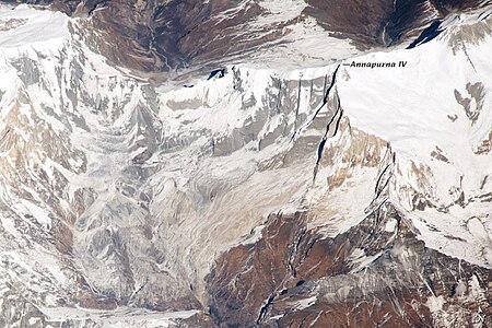
Rockfalls
Rockfalls from Annapurna IV are thought to have blocked the Seti River, creating a temporary dam.[1]
-
 Annapurna IV
 -
![The rockfall that temporarily blocked the river[1]](//upload.wikimedia.org/wikipedia/commons/thumb/3/3d/ISS038-E-020918ann.jpg/400px-ISS038-E-020918ann.jpg) The rockfall that temporarily blocked the river[1]
The rockfall that temporarily blocked the river[1]

![The rockfall that temporarily blocked the river[1]](/wiki/File:ISS038-E-020918ann.jpg)
See also
References
- ^ a b "Making Sense of Nepal's Seti River Disaster : Image of the Day". earthobservatory.nasa.gov. 22 December 2013. Retrieved 6 March 2020.