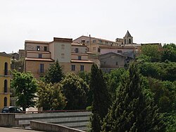
Isili
Appearance
Isili
Ìsili | |
|---|---|
| Comune di Isili | |
 | |
| Coordinates: 39°45′N 9°7′E / 39.750°N 9.117°E | |
| Country | Italy |
| Region | Sardinia |
| Province | South Sardinia |
| Government | |
| • Mayor | Orlando Carcangiu |
| Area | |
| • Total | 68.0 km2 (26.3 sq mi) |
| Elevation | 523 m (1,716 ft) |
| Population (31 December 2010)[1] | |
| • Total | 2,950 |
| • Density | 43/km2 (110/sq mi) |
| Demonym | Isilesi |
| Time zone | UTC+1 (CET) |
| • Summer (DST) | UTC+2 (CEST) |
| Postal code | 08033 |
| Dialing code | 0782 |
Isili, Ìsili in sardinian language, is a comune (municipality) in the province of South Sardinia, southern Sardinia, Italy, located about 60 kilometres (37 mi) north of Cagliari in the Sarcidano traditional region.
Isili borders the following municipalities: Gergei, Gesturi, Laconi, Nuragus, Nurallao, Nurri, Serri, Villanova Tulo.

Main sights
[edit]References
[edit]Wikimedia Commons has media related to Isili.


