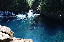
Tamolitch Falls
This article needs additional citations for verification. (March 2012) |

The Tamolitch Falls, now a seasonal waterfall, once had a constant flow on the McKenzie River in Linn County, Oregon. The site is located in the Willamette National Forest. In the 1960s, water was diverted for hydroelectric use from the stream above the falls; that section of the stream, as well as the falls, ceased to flow except during periods of heavy runoff or when water was diverted from the dams upstream. When this is not the case, the stream goes underground and now emerges below the falls. At the base of the former falls is the Tamolitch Blue Pool, a small body of water known for its blue color. Visitors to Blue Pool should note that water temperatures are extremely cold. Swimming is not encouraged or recommended.[1] The area is accessible via Oregon Route 126.
The site is very popular and parking at the trailheads fills up quickly. Make sure to have trail maps and adequate directions before heading out. Use is heavy during the spring and summer. To keep this place beautiful, please practice Leave No Trace ethics.
- Elevation:[clarification needed] 2,487 feet (758 meters)
References
- ^ "Willamette National Forest - Tamolitch Blue Pool". US Forest Service.
- "McKenzie River — Oregon". Retrieved 6 March 2012.
- "Tamolitch Falls, aka Blue Pool". Retrieved 6 March 2012.
- "Tamolitch Falls". Retrieved 6 March 2012.
External links
- https://web.archive.org/web/20110722102425/http://www.kval.com/younews/22696999.html
- https://web.archive.org/web/20110726211430/http://www.oregonwild.org/about/blog/waterfall-showcase-showdown
- Tamolitch Pool - McKenzie River
44°18′42″N 122°01′34″W / 44.311788°N 122.026172°W
