Jefferson, Kansas
Appearance
Jefferson, Kansas | |
|---|---|
 | |
| Coordinates: 37°06′44″N 95°45′41″W / 37.11222°N 95.76139°W | |
| Country | United States |
| State | Kansas |
| County | Montgomery |
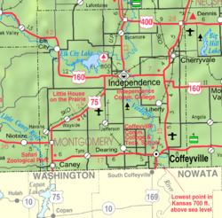
Jefferson is an unincorporated community in Montgomery County, Kansas, in the United States.
History
Jefferson was laid out in 1886 when the railroad was extended to that point. It was named for Albert Jefferson Broadbent, the original owner of the town site.[1]
A post office was opened in Jefferson in 1888, and remained in operation until it was discontinued in 1954.[2]
References
- ^ Duncan, L. Wallace (1903). History of Montgomery County, Kansas. Press of Iola Register. pp. 81.
- ^ "Kansas Post Offices, 1828-1961". Kansas Historical Society. Retrieved 16 June 2014.
External links


