
Lake Tritriva
| Lake Tritriva | |
|---|---|
 | |
 Lake Tritriva | |
| Coordinates | 19°55′44″S 46°55′29″E / 19.9290°S 46.9247°E |
| Type | Crater lake |
| Basin countries | Madagascar |
| Max. length | 200 m (660 ft)[1] |
| Surface elevation | 1,950 m (6,400 ft)[1] |
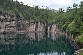
Lake Tritriva is a volcanic lake in southwest-central Madagascar, in the region of Vàkinankàratra, located near the village of Belazao. The lake fills an extinct crater[2] in a region notable also for the presence of many hot springs. It sits in the vent of an oval volcanic cone enclosed in vertical gneiss cliffs.[1] The rim of the cone is about 2,000 m (6,600 ft) above sea level, while the surface of the lake is approximately 50 m (160 ft) below the rim.[1] The lake's water level drops during the rainy season and rises when the monsoon rains have ceased.[citation needed]
Tritriva was drawn to the attention of the larger world by James Sibree, Jr. in 1885.[3]
Gallery
-

-
-

-
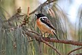 Madagascan stonechat found at Lake Tritriva
 -
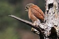 Malagasy kestrel found at Lake Tritriva


References
- ^ a b c d Scheffel, Richard L.; Wernet, Susan J., eds. (1980). Natural Wonders of the World. United States of America: Reader's Digest Association, Inc. p. 387. ISBN 0-89577-087-3.
- ^ "Madagascar: Tourism". Archived from the original on 2009-02-28. Retrieved 2007-06-09.
- ^ "The Volcanic Lake of Tritriva: Its Physical Features and Legendary History", The Antananarvio Annual and Madagascar Magazine (London Missionary Society) 1885:469-72.
This Vakinankaratra location article is a stub. You can help Wikipedia by expanding it. |