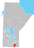
Île-des-Chênes
Appearance
Île-des-Chênes | |
|---|---|
Village | |
| Nickname: Island of Oaks | |
| Coordinates: 49°42′38″N 96°59′18″W / 49.71056°N 96.98833°W | |
| Country | Canada |
| Province | Manitoba |
| Government | |
| • Type | Rural Municipality of Ritchot |
| • MP (Member of Parliament) | Ted Falk (CPC) |
| Area | |
| • Total | 2.03 km2 (0.78 sq mi) |
| Population | |
| • Total | 1,253[1] |
| postal code | R0A 0T0 |
Île-des-Chênes is an unincorporated community in Manitoba, Canada, within the Rural Municipality of Ritchot. The community is located just east of Highway 59, approximately 10 minutes southeast of the provincial capital Winnipeg.
On August 31, 2000 a boil water advisory was issued for the Ile-des-Chênes community by Manitoba Health after water testing found the water supply well to be contaminated. The next year a C$6 million program funded through the Canada-Manitoba Infrastructure Program paid for the replacement of the supply pipes, distribution pipes, water treatment plant was undertaken and the project completed in 2002.[2]
References
- ^ "Ile des Chenes population data". Stats Canada. Retrieved April 23, 2014.
- ^ "Canada-Manitoba Infrastructure Program Funds New Water Supply for Ste. Adolphe and Ile-des-Chenes". gov.mb.ca. July 10, 2001. Retrieved February 13, 2020.
{{cite web}}: CS1 maint: url-status (link)
See also
External links
Wikivoyage has a travel guide for Île-des-Chênes.
49°42′38″N 96°59′18″W / 49.71056°N 96.98833°W


