
Ringlikon railway station
Ringlikon | |||||||||||
|---|---|---|---|---|---|---|---|---|---|---|---|
 | |||||||||||
| General information | |||||||||||
| Location | Ringlikon, Uitikon, Canton of Zurich, Switzerland | ||||||||||
| Coordinates | 47°21′36″N 8°28′39″E / 47.35999°N 8.477433°E | ||||||||||
| Elevation | 682 m (2,238 ft) | ||||||||||
| Owned by | Sihltal Zürich Uetliberg Bahn | ||||||||||
| Operated by | Sihltal Zürich Uetliberg Bahn | ||||||||||
| Line(s) | Uetliberg line | ||||||||||
| Platforms | 2 | ||||||||||
| Services | |||||||||||
| |||||||||||
Ringlikon is a railway station situated near to the village of Ringlikon in the municipality of Uitikon in Switzerland. The station is on the Uetliberg line, which is operated by the Sihltal Zürich Uetliberg Bahn (SZU).[1][2][3]
The station is served by the following passenger trains:[4]
| Operator | Train Type | Route | Typical Frequency | Notes |
|---|---|---|---|---|
| SZU | Zürich S-Bahn S10 |
Zürich Hbf - Zürich Selnau - Zürich Binz - Zürich Friesenberg - Zürich Schweighof - Zürich Triemli - Uitikon Waldegg - Ringlikon - Uetliberg | 2-3 trains per hour |
The station has a passing loop and two side platforms, and has no station buildings. Ringlikon village, which is some 700 m (2,300 ft) distant and 50 m (160 ft) lower, is linked to the station by a footpath.
Gallery
-
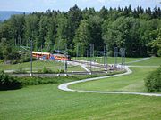 The station seen from path to Uetliberg
 -
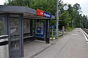 The station facilities


References
- ^ Zurich City Map (Map). 1:16000. Hallwag Kümmerlry+Frey AG. ISBN 978-3-8283-0070-5.
- ^ "Bahn S4/S10" [Railway S4/S10] (in German). SZU. Retrieved 2011-09-01.
- ^ Eisenbahnatlas Schweiz. Verlag Schweers + Wall GmbH. 2012. pp. 64–65. ISBN 978-3-89494-130-7.
- ^ "Zürich HB–Triemli–Uetliberg" (PDF). Bundesamt für Verkehr. 17 October 2019. Retrieved 24 December 2019.
External links
 Media related to Ringlikon railway station at Wikimedia Commons
This article about a railway station in Switzerland is a stub. You can help Wikipedia by expanding it. |